Colorado wildfires: Trio of uncontained fires in western part of the state consumes 44,000 acres, triggers evacuations
Published in News & Features
DENVER — Three wildfires burning in western Colorado have consumed roughly 44,000 acres, killed three firefighters and injured two, according to the responding agencies.
“Critical fire weather conditions” forecast each day this week could spur the wildfires’ growth across the state’s Western Slope and mountains, according to the National Weather Service’s Grand Junction office.
As of Monday morning, red flag warnings had been issued for most of southwest Colorado, including the Paradox Valley, North Fork Valley, Gunnison Basin and Colorado River Basin, according to the Grand Junction office. The warnings will be in effect from noon to 8 p.m. Monday, with wind gusts up to 40 mph and humidity as low as 7% expected.
“These conditions will drive very high fire danger across the warned area,” weather service forecasters wrote in a fire weather alert. “Any new starts or established fires will likely spread rapidly under these conditions.”
Red flag warnings were also issued for Boulder, Chaffee, Clear Creek, Douglas, El Paso, Fremont, Gilpin, Grand, Jefferson, Lake, Las Animas, Park, Pueblo, Summit and Teller counties, according to the weather service’s Boulder and Pueblo offices. Forecasters said up to 45 mph wind gusts and as low as 7% humidity are expected in those areas.
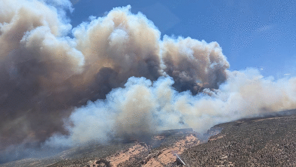
Snyder Mesa fire in Mesa County and Utah
Colorado’s largest wildfire is burning on nearly 30,000 acres on the Western Slope, near the Utah border, and has killed three firefighters, according to federal fire officials.
The Snyder Mesa fire started as four small fires — two in Utah and two on Colorado’s Western Slope. Utah’s Snyder Mesa and Jones fires spread across the Colorado border, merging and consuming the Knowles and Gore fires in Mesa County.
As the wildfire spread, the flames overtook five federal firefighters responding to the Knowles and Gore fires, according to the U.S. Wildland Fire Service, an agency created earlier this year to streamline firefighting and fire reduction across public lands.
The firefighters were caught in a “burnover incident” and deployed their shelters, but the wildfire killed three fire and injured two, U.S. Forest Service officials said. A burnover is when a wildfire overtakes firefighters or their equipment, leaving them no time to escape.
The firefighters who died were identified Monday morning by the U.S. Forest Service as 38-year-old Emily Barker of Michigan, 27-year-old Nick Hutcherson of Arizona and 27-year-old Sydney Watson of Alabama. An investigation has been opened into their deaths, federal officials said.
Colorado Gov. Jared Polis declared a disaster emergency for the Snyder Mesa fire on Saturday and authorized the use of the National Guard to fight the blaze. As of Sunday, the Snyder Mesa fire had consumed 29,152 acres with no containment, according to the Colorado Division of Homeland Security and Emergency Management.
The Mesa County Sheriff’s Office asked people to evacuate the potential path of the fire and to turn on irrigation water to saturate the land. The Bureau of Land Management closed public access to lands it manages nearby, including the McInnis Canyons National Conservation Area.
Pre-evacuation notices were issued on Sunday for residents living in the Glade Park area, the Kingsview subdivision and the Pollock Canyon Estates, according to the Mesa County Sheriff's Office. That includes the area south of the Colorado River to BS Road and west of Colorado 340. The sheriff also closed A 2/10 Road at DS Road and BS Road before the Bureau of Land Management boundary, the Kokopelli Trail Road between Loma and Mack and 16 5/10 Road to Glade Park at Monument Road and Rim Rock Drive, according to law enforcement.
The sheriff's office and the American Red Cross are operating a Snyder Mesa fire evacuation center at Grand Junction High School, 1400 N. Fifth Street.
Gold Mountain fire near Ouray
A wildfire burning near Ouray, a popular Colorado mountain town, multiplied in size on Sunday, consuming more than 4,000 acres, according to state officials.
The Gold Mountain fire sparked Saturday north of Ouray, forcing evacuations. It was first mapped at an acre on Saturday, grew to 572 acres by Sunday morning and had charred 4,217 acres as of that evening, according to the Colorado Division of Homeland Security and Emergency Management.
“Extremely steep and rugged terrain” has made fighting the fire difficult, county officials said.
Colorado Gov. Jared Polis issued a disaster declaration for the wildfire — which forced evacuations north of Ouray — on Sunday.
Mandatory evacuations included residents in and near Lake Lenore, Panoramic Heights, Redstone Road and Peck’s Trailer Park, as well as those living between the trailer park and Cedar Hill Cemetery, according to the Ouray County Sheriff's Office. Pre-evacuation notices were also issued for residents living on Ouray County Road 17 from the Whispering Pines area to the Black Lake area.
The city of Ouray had not been evacuated as of Sunday evening, but sheriff's officials said residents and visitors should be prepared for a pre-evacuation notice and start solidifying evacuation plans.
Evacuated residents can seek shelter at the Ridgway Secondary School, 1200 Green Street, according to county officials.
As of Monday morning, U.S. 550 remained closed in both directions between 10th Avenue and Ouray County Road 23 for the fire, according to the Colorado Department of Transportation.
Ferris fire in San Juan National Forest, near Dolores
Related Articles
• 3 wildland firefighters killed in western Colorado identified
• Colorado wildfires: Lake County fire prompts evacuations near Leadville
• She fought in a Denver court to save her dog’s life. She ended up sentenced to 90 days in jail.
• Denver’s municipal sentencing reform would go further than required — giving some council members heartburn
• Can hikers and mountain bikers get along? Some Colorado counties believe they can.
Three fires that sparked Saturday in southwestern Colorado's San Juan National Forest have now merged into one, consuming more than 10,000 acres with no containment, according to federal officials.
As of Sunday evening, the Ferris, Far Draw and Doe Canyon fires had scorched an estimated 10,637 acres, according to the U.S. Forest Service. An updated size estimate was not yet available on Monday, but officials said the wildfire would move forward under the Ferris fire name.
Fire officials believe lightning sparked all three wildfires in the San Juan National Forest's Glade area near Narraguinnep Canyon, north of Dolores, according to the Forest Service.
Mandatory evacuations were issued Sunday for residents north and east of the wildfires, according to the Dolores County Office of Emergency Management. The evacuation area was bordered to the north by Disappointment Road, to the south by the Glade Ranch community, to the west by the fire and to the east by Road 30, according to the office.
The U.S. Forest Service also closed the Bradfield Bridge Campground, Forest Service Road 504 to the base of McPhee Dam, Forest Service Road 521 and Forest Service Road 504 “out of an abundance of caution,” federal officials said.
Dry, hot and windy conditions exacerbated the fires' growth on Saturday and Sunday, and that weather is expected to continue throughout the next several days, San Juan Team Eight Incident Commander Brad Pietruszka said in Sunday's operational briefing.
----------
©2026 MediaNews Group, Inc. Visit at denverpost.com. Distributed by Tribune Content Agency, LLC.


Comments