Odds climb for 1 of 2 Atlantic systems to develop, hurricane center says
Published in News & Features
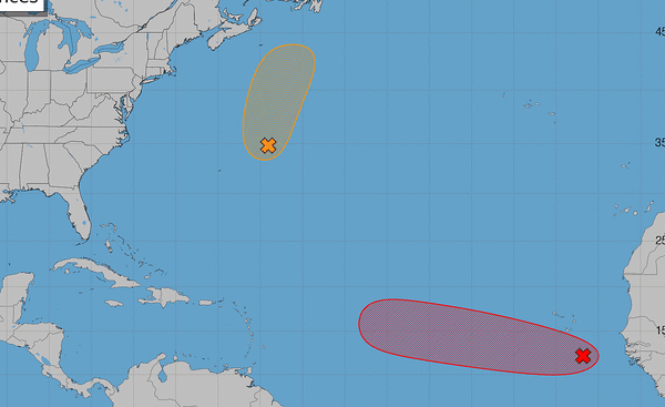
ORLANDO, Fla. — The National Hurricane Center on Tuesday increased the odds one system in the Atlantic could become the next tropical depression or storm, while dropping chances on a second Atlantic system it had been tracking.
As of the NHC’s 8 a.m. tropical advisory, the more likely of the two, and the one of more concern to Florida, was an area of low pressure in the eastern tropical Atlantic a few hundred miles south-southeast of the Cape Verde Islands with disorganized showers and thunderstorms. The NHC has dubbed the system Invest 96L.
“Environmental conditions appear conducive for gradual development, and this system is likely to become a tropicaldepression during the next day or two while it moves westward to west-northwestward across the eastern and central tropical Atlantic,” forecasters said. “Environmental conditions could become less conducive for developmentby the weekend.”
The NHC gave the system a 70% chance to develop in the next two to seven days.
Levi Cohen with the hurricane-tracking site tropicaltidbits.com said the Saharan air mass to the system’s north is less dry and deep than usual, which helps favor development.
“Models agree on a west-northwestward track that would bring the system near or north of the Lesser Antilles in 6-7 days,” he posted on X late Monday. “96L will likely encounter a less favorable environment later in the week as it nears a persistent zone of elevated wind shear over the central Atlantic.”
Despite noting that earlier tropical waves had been destroyed in this zone, Cohen said that because it is peak hurricane season, the system could survive long enough through the zone.
“It’s too early to know whether 96L will stick around beyond this week, but it is a system to watch,” he said.
The other system being tracked by the NHC, which is no threat to Florida, was an area of low pressure named Invest 95L in the central subtropical Atlantic a few hundred miles east-northeast of Bermuda moving north at 15-20 mph.
“The associated shower activity remains disorganized and the circulation is broad and elongated. This system could still become a short-lived tropical depression or storm later today before encountering increasingly hostile conditions tonight and Wednesday likely ending its chances for development,” forecasters said.
The NHC dropped its forecast to a 40% chance that it would develop in the next two to seven days.
Either system, if it grows strong enough, could become Tropical Storm Dolly with Tropical Storm Edouard potentially up next as well.
So far the 2026 Atlantic hurricane season, which began June 1 and runs through Nov. 30, has been slow with only three named systems: Tropical storms Arthur, Bertha and Cristobal.
The National Oceanic and Atmospheric Administration earlier this month updated its seasonal forecast and now expects between seven and 13 named storms this year. Of those, two to six would become hurricanes. It also predicted that there might not be any major hurricanes this year, or at most two.
Already, 2026 was forecast to have lower-than-average storm generation, and that has been reduced even further with the latest forecasts from the NOAA and other weather groups.
An average year would see 14 named storms and seven hurricanes, with three of those growing to Category 3 strength or higher.
The height of hurricane season runs from mid-August through mid-October.
------------
©2026 Orlando Sentinel. Visit at orlandosentinel.com. Distributed by Tribune Content Agency, LLC.






Comments