Nor'easter to linger around Massachusetts coast through Monday
Published in News & Features
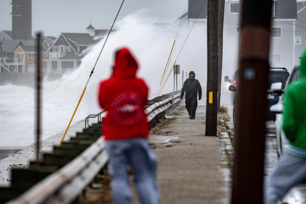
After a soggy weekend, the Boston region can expect more wind and rain but less intense conditions as the nor’easter lingers through Monday before conditions begin to dry out Tuesday, according to National Weather Service forecasts.
“The nor’easter is actually sitting off the coast of New Jersey right now,” said NWS meteorologist Torry Dooley. “As it moved north towards southern New England, it jogged over to the west. So it’s sitting there now, and it’s really lost a lot of its steam. And it’s going to be moving back to the northeast throughout the day (Monday). So folks should anticipate this gloomy weather continuing into Monday.”
After hitting southeastern Massachusetts Friday night and continuing through the weekend, storm conditions are expected to finally clear the region around Tuesday heading into sunnier, warmer conditions around mid-week, forecasts show.
For Monday though, residents can expect more rain and wind, as coastal flood advisories and flood watches remain in place for Boston through the night.
“There will be some breezy wind, but not to the level that we’ve seen the last few days,” Dooley said. “Would anticipate the wind gust will probably be in the 20 to 30 mile per hour range.”
Additional rainfall into Monday is likely to reach up to about an inch for eastern Massachusetts, Dooley said, contributing to continued poor drainage flooding.
As of Sunday night, power outages dipped just below 1,000 across Massachusetts, according to Massachusetts Emergency Management Agency data, down from a peak over 10,000.
Rainfall total for the weekend in southeastern Massachusetts ranged around three to five inches locally, with some higher totals over six inches. The Blue Hill Observatory in Milton recorded 7.82 inches as of around mid-day Sunday, one of the “more impressive rainfall totals,” Dooley noted.
Wind gusts ranged between 40 and 60 miles an hour, with a few instances of gusts above 60 miles an hour along the immediate shore of eastern Massachusetts, the meteorologist noted. Around Boston, the biggest gust at Logan airport registered up to 53 mph Saturday night.
“We’ve received reports of mainly minor damages,” said Dooley. “Most of them were down limbs or trees under power lines. We’ve also received reports of some minor flooding in the Brockton area, where photos were sent to us where cars were submerged up to their wheel wells.”
Videos also came in from Scituate with larger waves breaking onto homes, he added, noting they are not sure how much damage occurred yet.
In terms of “catastrophic damage,” Dooley noted Sunday night, nothing was reported to NWS “at this time.”
“After some really awful weather, we’ll have at least a bit of a break by the middle part of the week,” Dooley said.
The Boston area can expect conditions to dry out Tuesday, with some early showers possible, a high around the mid-60s and cloudy conditions continuing throughout the day, forecasts show.
“The clouds will probably linger on Tuesday, unfortunately, before we try to break out into a mixture of some sun maybe by late midday on Tuesday at the earliest,” Dooley said. “But the rest of this coming week is fairly inactive weather-wise, and actually we’ll have temperatures returning to about the middle 70s.”
Wednesday and Thursday are forecasted to see mostly sunny conditions return and highs from the low to mid-70s, and the trend looking to continue Friday heading into the weekend.
________
©2026 MediaNews Group, Inc. Visit at bostonherald.com. Distributed by Tribune Content Agency, LLC.






Comments