San Jose declares local emergency amid El Niño flood risk
Published in News & Features
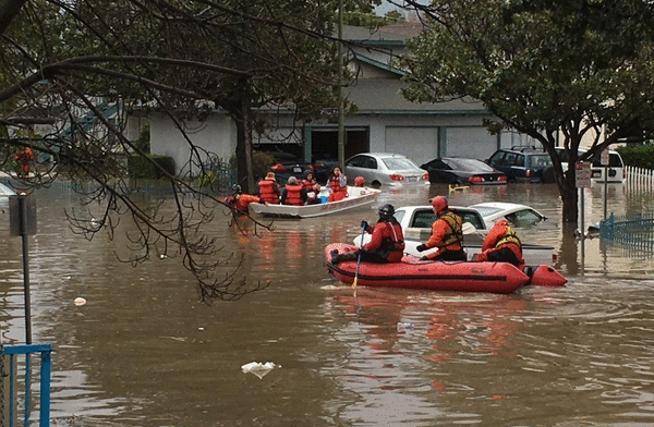
SAN JOSE, Calif. — San Jose declared a local emergency Tuesday to speed flood preparations and make $5.5 million in city reserves available ahead of a winter that officials and residents fear could threaten neighborhoods devastated by flooding in 2017.
Taking effect immediately, the declaration cuts bureaucratic red tape to fast-track emergency contracts and gives city management the legal authority to enforce mandatory evacuations and reassign staff should storm conditions worsen.
The move comes almost a decade after the catastrophic February 2017 floods, which inundated several neighborhoods with muddy water, damaged more than 500 homes, and forced the evacuation of 14,000 residents — mostly around Rock Springs, Naglee Park and nearby mobile home parks. Emergency officials said lessons from that disaster are guiding their immediate preparations, even as broader capital projects remain years out. The second phase of flood protection along Coyote Creek is slated for completion in 2028, while comprehensive defenses for Upper Penitencia Creek and the Upper Guadalupe River stretch into the 2030s.
With memories still fresh of neighborhoods receiving little to no warning in 2017, officials from the city and the Santa Clara Valley Water District also delivered progress reports on joint response agreements and major flood mitigation projects aimed at protecting vulnerable areas.
The emergency declaration carries no set expiration date, instead requiring staff to report back to the City Council every 60 days so councilmembers can decide whether to extend or end the emergency status.
Federal forecasters expect a very strong El Niño this winter, increasing the odds of wetter-than-average conditions across much of California. But the pattern does not guarantee heavy rainfall or flooding in San Jose.
While the two agencies have previously been criticized for passing the buck on jurisdiction, Mayor Matt Mahan said he was pleased to see the city and water district collaborating in a “much more proactive and effective way.”
Emergency Management Director Ray Riordan said a critical part of the joint emergency action plan is for the two agencies “to call each other.”
“We actually have regular Zoom calls with the county, also directly with Valley Water,” Riordan said.
Through those regular briefings, Riordan said agencies translate scientific jargon into plain language that residents can easily grasp.
“The last thing I wanted to hear — which we did hear in 2017 — is ‘3,000 cubic feet per second, don’t you understand that?’ Well, no,” Riordan said. “We want to know better and talk in lay terms. So we spend a lot of time dialoguing to understand.”
Adopted after the 2017 disaster and reviewed each fall, the joint plan relies on a four-tier system based on rising water levels rather than sharing numbers-heavy announcements.
The tiers measure water depth against the point where banks begin overflowing. “Preparedness” applies when streams are less than half-full, shifting to “monitoring” at 50%, and escalating to a “watch” with public notifications when water reaches 70% of bank-level. A “warning” is deployed when forecasts show creeks likely to spill over within 24 hours. While officials do not have to wait until waters reach that final threshold to order evacuations, the tiers provide a clear baseline for reacting to specific threats beforehand.
Councilmember Domingo Candelas said he appreciated the two agencies tightening coordination and hashing out among themselves who is responsible for what.
He pointed out that jurisdictional issues are for government agencies to sort out, because as far as residents are concerned, they don’t distinguish responsibilities — “they just see government.”
“And the fact that whether it’s a fallen branch, a flooded trail, or damaged infrastructure, that we’re working together … is important. This isn’t how it was years ago,” he said.
Valley Water officials told the City Council that crews have used the recent dry stretch to prepare the city’s waterways and storm infrastructure ahead of the rain.
“It’s much better to take preventative actions when there is no rain, rather than to try to get out there in an emergency and take actions when basically it’s unsafe at that point in time,” said Christopher Hakes, chief operating officer of watersheds for Valley Water.
As long-term solutions remain years ahead, crews have focused immediate efforts on clearing waterways. Valley Water has already completed 167 stream-clearing projects this season, and the city is seeking emergency state environmental permits to enter private or unmanaged parcels to clear severe tree blockages along Coyote Creek.
The emergency declaration also requires all city departments to share personnel and equipment, covering initial costs out of regular departmental budgets before tapping the $5.5 million reserve fund.
If costs escalate beyond that, the city can authorize spending from its $29.6 million contingency reserve, the city’s budget office told this news organization, while positioning San Jose to seek state and federal disaster reimbursement.
Free sandbags are already available at five countywide depots, including three within San Jose. In addition, officials distributed 48,000 door hangers to creekside homes, pointed residents to an address-searchable online flood-risk map, and readied Long Range Acoustical Devices to broadcast emergency alerts.
Herb Bowen of San Jose’s Community Emergency Response Team told council he hoped some funds would be available for community outreach to help neighborhoods understand the risks and how to prepare for them.
“There’s a lot of fear and anxiety about this because some people were flooded out in ’17,” he said. “So I’m hoping we can pull a little bit out and help the different districts get the word out.”
San Jose is urging residents to prepare by signing up for alerts at AlertSCC.org, creating an emergency plan and stocking their supply kits. Residents can find storm resources at bit.ly/SJ-StormReady or check their specific flood hazard zone using the city’s interactive map available on the Mercury News website.
_____
©2026 MediaNews Group, Inc. Visit at mercurynews.com. Distributed by Tribune Content Agency, LLC.






Comments